Search This Blog

Showing posts with label Hiking. Show all posts

Monday, July 4, 2011

Big Ridge Hiking on July 4

From Blogger Pictures

On July 4, 2011, my father and I went hiking at Big Ridge State Park in Maynardville, TN (about 25 miles from my parents homes). The area of land and the creation of the park have an interesting history. Toward the end of the 18th century (1791), Henry Sharp, Nicholas Gibbs (the name sake of the high school I attended in Tennessee), Levi Hinds, and the Graves family settled in the region known as East Tennessee. The land of Big Ridge State Park was on land ceded to the United States by the Cherokee Nation in the Holston Treaty. At the foot of Big Ridge these families built Sharp's Station. Just off of the five mile Big Ridge loop trail is "Indian Rock." This is where Peter Graves was attacked and killed by Indians on 13 November 1794. Peter Graves was the first person buried in the Sharp's Station cemetery. A month after Graves was killed, the Indians attacked Sharp's Station but the residents were able to successfully ward off the attack.

From Blogger Pictures

In the mid-1930s, the Tennessee Valley Authority purchased sections of land in East Tennessee. Included in the property purchase was what would become Big Ridge State Park, which was one of the five demonstration parts constructed by the TVA. 

From Blogger Pictures

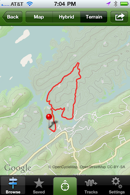
We hiked the five mile loop trail at Big Ridge. The loop trail is not a particular trail but pieces of other trails. In total, there are eleven trails at Big Ridge. We started on the Lake Trail (1.5 miles). This trail begins easy but has a moderate climb. Before crossing over the Big Ridge Dam, we hiked up to Loyston Lookout. This involved a climb of several hundred feet to a view of Loyston Sea (the widest part of Norris Lake), which flooded the city of Loyston, first settled in the early 1800s by John Loy, after the completion of Norris Dam in the mid-1930s. (Think of the events behind the movie Deliverance.)

From Blogger Pictures

(View of Loyston Sea from the Loyston Lookout.)

We then crossed Big Ridge Dam which separates Big Ridge Lake from Norris Lake.

From Blogger Pictures

(Big Ridge Lake)

From Blogger Pictures

We then proceeded onto West Dark Hallow Trail (1.7 miles).This trail was once a country road along which settlers made their homes. 

From Blogger Pictures

We came to the junction of West Dark Hallow, Big Valley, East Dark Hallow and Indian Rock Loop trails near the Langely Cemetery. 

From Blogger Pictures

We walked along the Big Valley trail to Chestnut Ridge for another 1.3 miles. Essentially, we walked around Pinnacle Ridge. We concluded by walking on the road back to the park office, passing the Norton Grist Mill.

From Blogger Pictures

The Norton Gristmill was constructed in 1825 by Tink McCoy who turned it over to Lewis Norton. 

From Blogger Pictures

Big Ridge is a short distance from Knoxville and has easy to moderate level trails with a total climb of 1200 feet. Several online reviewers have noted that the trails are not well maintained and are not well marked. This is true. However, neither of these situations should prevent more experienced hikers from enjoying the trails. In addition to the aforementioned trails, there is a backcountry trail for overnight camping. On reviewer stated a hiker should get a map and keep a compass with him while on the trails because of the poorly marked trails. This is an exaggeration regarding the conditions of the trails and the difficulty in figuring out where one is going. All in all it is a good trail to hike.

From Blogger Pictures

For this hike I used the AllTrails program for the iPhone. It has access to 40,000 hiking trails and downloads a topographical map of the trail, as well as tracks your progress along the way. It has an accompanying website (www.alltrails.com). The iPhone app can be downloaded from the iTunes store.

From Blogger Pictures

From Blogger Pictures

Sunday, November 28, 2010

House Mountain Hike

West Overlook of House Mountain in Knox County
On the day my family and I drove back to Saint Louis from Knoxville, Tennessee -- after I had spent a week in Nashville for the Fall Leadership Conference, my son, my father, me, and Coco, an English Cockerspaniel hiked to the top of House Mountain in Knox County. House Mountain is the highest point in Knox County, rising 2,100 feet above sea-level. While the ground is hilly, this is East Tennessee, this ridge seems to rise out of nowhere above the surrounding landscape. This mountain is about 8 miles or so from my parents house and a place that I have hiked and bicycled many, many times.  The geologists say House Mountain was formed when the North American plate collided with Africa, resulting in the ground here in Knox County to buckle, forming the "mountain." As for the date of this event -- well no point in quibbling over a few years -- at least in my mind occurred when Noah and his crew of seven (total of eight) was sailing his ark around the world. You can read about House Mountain at the official Tennessee State Government website here or on Wikipedia here.


The 3 mile hike took us a little less than 1 1/2 hours, but keep in mind it is a 1,000 foot climb up, plus a boy and a dog. Well, the dog was no problem. She charged ahead, even climbing the rock ledge of the West Overlook by herself. While she had no fear of the ledge, we did and thought it best to help her down lest her descent be more rapid than anyone, including her, would like.

Coco on the rock ledge
View from Top of House Mountain
It always is difficult to capture what the view looks like. Below is a video that might give a little better idea. Seeing this kind of makes me want to sing Rocky Top.


Here are some more photos from the hike up House Mountain. Below the photos is a map of the House Mountain State Nature area.


House Mtn

Thursday, March 18, 2010

Chubb Trail

Entrance to Chubb Trail

This past weekend, I went to the Chubb Trail with my son, Kit, and my father. Instead of biking the trail, we hiked it. I can't wait to go cycling on the trail. Chubb Trail looks to be more challenging than Castlewood; the first part of the trail appeared to have some technical areas that would be more difficult on the bike. Once past the beginning part the trail seems straightforward. The trail is described here:

"The Chubb is the most challenging trail in the St. Louis area. It is a seven-mile dirt and gravel trail between West Tyson County Park and Lone Elk Park (14 miles round-trip). It has very challenging hills and some very fast stretches. Terrain is rocky and usually slippery. There are some truly nasty drop-offs. After those tough climbs you are often rewarded with great views."


Kit sitting on a rock
Map of Chubb Trail (from GORC)


Interesting tree on trail


Example of the Trail


Saturday, February 27, 2010

Hiking in Castlewood State Park

View of Meramec River from Bluff 250ft above

Castlewood State Park is the site of a former resort area popular at the beginning of the 20th century. People would take the train from downtown Saint Louis to Castlewood. The park is a little larger than 1800 acres. The park offers hiking, biking, horse back riding, etc. and stretches about 5 miles along both sides of the Meramec River. 

This park is only a few miles from my home. During the summer, I go mountain biking in the park. There are some good trails and the park is very popular. To see a larger version of any photo, click on the picture.


Limestone bluffs that are reminisce of castle walls

A Doe with two Fawns on the Trail along Meramec


Satellite Track of the Hike (Click Photo for Larger Image)


Map of Castlewood (Click Image to Enlarge)

Monday, February 22, 2010

Columbia Bottom Conservation Area


This past Saturday Kit and I went to Columbia Bottom Conservation Area in North Saint Louis. The park is 4,300 acres at the confluence of the Missouri and Mississippi Rivers. This entire area was under about 15 feet of water during the great flood of 1993 -- the year I first moved to Saint Louis. Kit and I walked just under 7 miles. The first half of our trip we walked along the river's edge; the second part we walked along the concrete road. At the confluence point, there are benches with sayings about Missouri and Mississippi Rivers. One saying said, "The Missouri River is to think to drink but too thin to plow." The park also has about 4 miles of paved trails that suitable for walking, jogging, or cycling. We saw deer on our walk along the river, an eager, and flocks of water fowl. See below for photos and maps.

(Click Photo for Larger Size)
SportyPal GPS track of the first part of the walk.


Kit at the River's Edge Trail

View Along River's Edge


Muddy Boots after Leaving Trail


(Click Photo for Larger Size)
SportyPal Track of Return Walk


Flocks of Birds


(Click Map for Larger Image)
Columbia Bottom Conservation Area

Tuesday, February 16, 2010

Powder Valley Winter Lunch Walk


Nestled between I-44 and I-270 is Powder Valley Conservation Nature Center, a 155 acre park on the border of Kirkwood and Sunset Hills, MO. . Fortunately for me, Powder Valley is about a 7 minute drive from where I work, allowing me to go walking there during my lunch break. The park has four short trails, each of which can be walked in 30 minutes or less. The longest trail is about 1.1 miles. Powder Valley even has a blog site describing current conditions, featured animals, and upcoming events. The park provides a little respite from the city and a break from the office. One of my goals this year is to visit as many of the 50 plus conservation areas in the greater Saint Louis, MO area. After I visit the site, I will post something on the blog with a few photos and my hike from SportyPal. I do not know many metropolitan areas that have such a rich park system as Saint Louis.

Today, the trails at Powder Valley were open but snow covered. I wore the wrong shoes, as my dress boots do not really have the necessary traction for slippery conditions. The trails are paved with asphalt, making it a relatively easy walk (except in icy conditions). A variety of wildlife can be seen in the part ranging from frogs, to birds, to deer. The park also has a very nice nature center that features a number of exhibits including a Missouri River exhibit of live fish. A visit to Powder Valley is worth your time.

Two of the Eight Deer I Saw


Creek in Powder Valley


SportyPal/Google Earth View of Powder Valley (click for larger image)


Map of Powder Valley (click for larger image)

Sunday, February 14, 2010

Snow, Lime Kiln Loop Trail, and SportyPal


Snow in the Rockwood Reservation

Today was a rather good day all around -- the Feast of the Transfiguration of our Lord, Valentine's Day, and snow in Saint Louis, MO. I grew up in Michigan and always have enjoyed the snow. It is a rare treat to have nice, fluffy snow -- the kind of snow that comes when the air temperature is about 29 °F. The snow brought back memories of cross-country skiing in Michigan, so I went hiking. Several inches of snow fell, making the roads slick -- in fact, I watched two teenage girls drive their car into a guard rail on a hill and then helped them get their car back on the road, as I drove to the Rockwood Reservation (Click Here for the Missouri Department of Conservation Page) in Wildwood, MO.  

Missouri has many great parks suitable for hiking and cycling (my major outdoor activity from April through October). According to the brochure, the Rockwood Reservation "was established in 1938, making it one of the oldest Conservation Areas. The 1,880-acre area provides opportunities to enjoy and learn about Missouri's fish, forest and wildlife resources through hiking trails, the Education Center and naturalist-led interpretive programs." Rockwood Reservation has springs, caves, and interesting rock formations as well as a variety of animal life.

Old Lime Kiln at head of the trail


I hiked the Lime Kiln Loop Trail, which features a lime kiln from the 19th century. The trail itself is about 3.1 miles long, one of the longest trails at the Rockwood Reservation. From the lowest to the highest elevation of the trail, a person will climb 300 feet -- not quite like hiking House Mountain in Knox County Tennessee, which is a climb of 900 feet over a mile -- enough to get a pretty good work out. The snow was quite a contrast to the tropics of Haiti. After a few pictures, the text continues with a brief discussion of SportyPal.

View Along The Trail


The Red Circles Indicate Deer


Creek Along the Trail


Rockwood Reservation (Click on Map to Enlarge)

When I go hiking, cycling, or walking around the neighborhood, I use a program called SportyPal. This is a great program that runs on your smart phone. Currently, the program runs on Windows Mobile, iPhone, Android phones, phones that run Java, and a few others. When you start the program, you tell it what kind of a workout you plan to do -- walking, cycling, free-style, running, skiing, etc. The program uses the GPS feature of your phone to track your speed, altitude, and distance traveled. Based on the type of workout selected, the program estimates how many calories you burned while exercising. While exercising, your phone continues to work as normal -- so you can receive text messages, email, phone calls, etc. The program also allows you to take photos along your exercise path (the photos above were taken while SportyPal was running). Once you are finished with your workout, the program allows you to upload the data to a website. This is where things get cool. Your path is plotted out on a Google Map (see below). Best of all the program and the web account are free. I highly recommend it.

My Hike at the Lime Kiln Loop (click to enlarge)