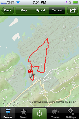
On July 4, 2011, my father and I went hiking at Big Ridge State Park in Maynardville, TN (about 25 miles from my parents homes). The area of land and the creation of the park have an interesting history. Toward the end of the 18th century (1791), Henry Sharp, Nicholas Gibbs (the name sake of the high school I attended in Tennessee), Levi Hinds, and the Graves family settled in the region known as East Tennessee. The land of Big Ridge State Park was on land ceded to the United States by the Cherokee Nation in the Holston Treaty. At the foot of Big Ridge these families built Sharp's Station. Just off of the five mile Big Ridge loop trail is "Indian Rock." This is where Peter Graves was attacked and killed by Indians on 13 November 1794. Peter Graves was the first person buried in the Sharp's Station cemetery. A month after Graves was killed, the Indians attacked Sharp's Station but the residents were able to successfully ward off the attack.
In the mid-1930s, the Tennessee Valley Authority purchased sections of land in East Tennessee. Included in the property purchase was what would become Big Ridge State Park, which was one of the five demonstration parts constructed by the TVA.
We hiked the five mile loop trail at Big Ridge. The loop trail is not a particular trail but pieces of other trails. In total, there are eleven trails at Big Ridge. We started on the Lake Trail (1.5 miles). This trail begins easy but has a moderate climb. Before crossing over the Big Ridge Dam, we hiked up to Loyston Lookout. This involved a climb of several hundred feet to a view of Loyston Sea (the widest part of Norris Lake), which flooded the city of Loyston, first settled in the early 1800s by John Loy, after the completion of Norris Dam in the mid-1930s. (Think of the events behind the movie Deliverance.)
(View of Loyston Sea from the Loyston Lookout.)
We then crossed Big Ridge Dam which separates Big Ridge Lake from Norris Lake.
(Big Ridge Lake)
We then proceeded onto West Dark Hallow Trail (1.7 miles).This trail was once a country road along which settlers made their homes.
We came to the junction of West Dark Hallow, Big Valley, East Dark Hallow and Indian Rock Loop trails near the Langely Cemetery.
We walked along the Big Valley trail to Chestnut Ridge for another 1.3 miles. Essentially, we walked around Pinnacle Ridge. We concluded by walking on the road back to the park office, passing the Norton Grist Mill.
The Norton Gristmill was constructed in 1825 by Tink McCoy who turned it over to Lewis Norton.
Big Ridge is a short distance from Knoxville and has easy to moderate level trails with a total climb of 1200 feet. Several online reviewers have noted that the trails are not well maintained and are not well marked. This is true. However, neither of these situations should prevent more experienced hikers from enjoying the trails. In addition to the aforementioned trails, there is a backcountry trail for overnight camping. On reviewer stated a hiker should get a map and keep a compass with him while on the trails because of the poorly marked trails. This is an exaggeration regarding the conditions of the trails and the difficulty in figuring out where one is going. All in all it is a good trail to hike.
For this hike I used the AllTrails program for the iPhone. It has access to 40,000 hiking trails and downloads a topographical map of the trail, as well as tracks your progress along the way. It has an accompanying website (
www.alltrails.com). The iPhone app can be downloaded from the iTunes store.


That looks like fun. I'm glad they let you out of the IC long enough to do some "normal" type stuff ;-)
ReplyDeleteWhat a wonderful history lesson and a lot of fun exploring the past. There is so much history that we never see because we are so busy. Thanks for sharing! August Thurmer
ReplyDelete